Illustration & Motion
Apr '24
Things to consider when creating an illustrated visitor map with character

Tom Bradley in Illustration
Related services
Illustrated maps can capture the essence and personality of a place, embodying its character and charm in a visually captivating way.
At Root Studio, we have a great deal of experience in map-making and understand the value of these maps in communicating the unique personality of a town, city or attraction.
In this article, we'll delve into the many considerations that you and your designer should make whilst crafting your illustrated visitor map.
Early considerations
Before diving into the creative process, it's crucial to lay the groundwork for your illustrated map.
Start by defining the boundaries of your map, considering the geographical area that you need to cover. Whether it's a compact depiction of a small visitor attraction, a detailed city centre map or an expansive, sprawling landscape - clarity on boundaries is a very useful starting point.
Next, consider the various formats and contexts in which your map will be used. Will it be used on large format signage or fold out for on-the-go exploration for example? Tailoring the illustration style, scale and method to suit these formats ensures optimal legibility and usability.
Determine your map’s primary function - is it for general wayfinding? Is it detailing a specific trail or route? Or is it highlighting hidden gems and local facts? Understanding this will guide decisions on what to include and the hierarchy of certain elements within the design.
Consider the story that you’d like to tell. An illustrated map is a great opportunity to transport its users into your own curated world. Think about the narrative you’d like to tell and how this could be achieved or supported within the map design.
As you craft your map, keep scalability and editability in mind. A map produced as a vector graphic for instance, will seamlessly adapt to different sizes and mediums without compromising its visual integrity whereas a hand-painted map is more difficult to scale upwards or amend at a later date.
Branding elements such as a specific colour palette, brand fonts and the inclusion of various funder/supporter logos should also be highlighted at the start of the process to ensure that they’re fully considered during the early stages of the design process.
Pick your landmarks & perspective
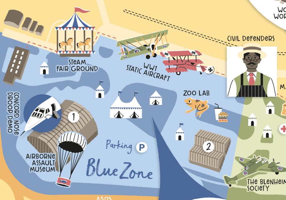
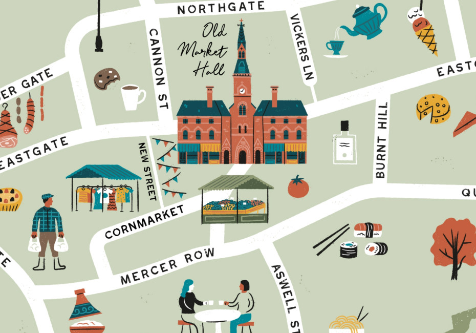
The highlighting of various prominent landmarks will form the backbone of your illustrated map. Whether you choose to focus on iconic buildings or natural features, carefully curate a selection of landmarks that help to give a sense of place and provide a useful reference point for users.

Once you’ve done this, consider the style in which you’d like these to be showcased. This could be a flat, 3D, top-down, isometric with a vanishing point or axonometric with no vanishing point for instance. Your designer should be able to share some examples of different perspectives for you to consider.
Add your icons, labels & key
Depending on the intended purpose of your map, you may wish to have a custom set of icons produced to place around your map. These might be used to help identify local amenities like coffee shops, parking spots or public conveniences. If you do include icons then don’t forget to include a key to help users understand what they’re making reference to.

Add personality & context
This really comes back to storytelling. Consider adding characters performing local activities, depict local celebrities or folklore or include pull-out illustrations of local delicacies to inject life into your creation and to support your narrative.
Top tips
Collaborate closely with your designer and invite them to immerse themselves in the location to gain firsthand insights and inspiration.
Where possible, provide visual references such as drone footage or aerial photography to guide the authenticity and accuracy of the design process.
Get started
In conclusion, crafting an illustrated visitor map is a labour of love that requires meticulous planning and creative vision. By following the steps outlined in this article, you'll be well-equipped to create a map that not only navigates but also narrates the story of your town, city or attraction. If you’d like to commission our illustrators to produce a map for you get in touch.
Thanks for reading
For more news follow us @rootstudiouk
Similar posts
Your hero image makes an impression before a single word is read. Here's the science behind why it matters and how to get it right.

Ever walked into a shop and immediately had a sales assistant on your shoulder? That tension you feel - that instinct to say "Er, just browsing thanks!" - is the hard sell doing its damage. There's a quieter, smarter way to bring clients to your door.